
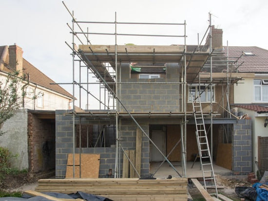
In 2026, more homeowners than ever are searching for properties they can customize, expand, and transform into their dream homes. Whether it’s adding square footage, reimagining outdoor space, or modernizing an outdated layout, renovation offers exciting possibilities. But without proper planning—and a clear, detailed site plan—those possibilities can quickly turn into costly setbacks.
Home improvement projects aren’t just about design and construction. They involve zoning regulations, permitting requirements, property lines, and neighborhood guidelines. Overlooking these details can lead to unexpected financial penalties, project delays, or even legal complications.
It’s also important to remember that renovations don’t happen in isolation. Exterior upgrades like additions, fences, driveways, or detached structures can unintentionally cross property boundaries or violate local setback rules. If you live in a community governed by a homeowners association (HOA), you may also need approval before breaking ground.
Careful planning at the start of your renovation isn’t just smart—it’s essential for protecting your investment and ensuring your vision becomes reality without unnecessary obstacles.
Besides making sure you perform renovations that you really need, you also need to ensure that your home construction project is up to code, especially exterior projects. And that is why you need a site plan before you start a building project.
Below, we discuss everything you need to know about a site plan, including what it is, why it’s important, when you need one, and how to draw it.
Table of contents
What is a site plan?
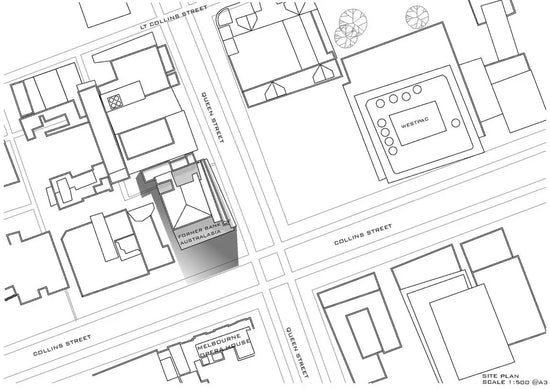
A site plan is a scaled drawing that shows a property’s boundaries and key features—like buildings, setbacks, driveways, utilities, and drainage—so you can plan construction and meet local permitting requirements.
A site plan, also known as a plot plan, is a diagram that shows proposed improvements to a property. If you need one for a permit, you can order a professional site plan online from My Site Plan. Typically, it includes both what already exists on a specific property and what you're proposing to build on that same property. This could, for example, include a building addition, such as a garage.
One of the most important features of a site plan is to show the relationship between what already exists and what you're planning to build.
Site plans are all created differently; they will not all be designed equally. This is because different building authorities will require different things. With some permits, you’re required to hire a land surveyor, whereas with others, you can draw the plan yourself on graph paper. You will need to check with your permitting department for clarification on this point before proceeding.
What is the difference between 2D and 3D site plans?
When it comes to site plans, you'll generally encounter two main types: 2D and 3D. A 2D site plan is a straightforward, bird’s-eye view drawing—think of it as a map of your property, outlining boundaries, structures, driveways, and other features with simple lines and labels. This approach is practical for most permitting needs and is often what city or county review boards expect when you submit plans.
On the other hand, a 3D site plan takes things a step further. Instead of a flat, technical sketch, you’ll see your property brought to life with color, depth, and realistic elements like trees, gardens, patios, and parking areas. 3D renderings are perfect if you want to visualize how new features will actually look in context—especially helpful for landscaping, outdoor living spaces, or when you're presenting ideas to an HOA.
In short:
- 2D plans are best for technical requirements, measurements, and municipal approvals.
- 3D plans excel when you want a full-color, realistic preview of proposed changes to share with contractors, neighbors, or design teams.
Why is a site plan important?
A site plan is important for four key reasons. It serves to ensure that you’re adhering to local building and zoning codes, that the local services can support these changes, that you’re using the land properly, and that there is an official record of all changes made to the property.

Other Uses for a Site Plan Beyond Construction
While site plans are crucial for getting the green light on new builds and renovations, their role doesn’t stop once the construction dust settles. In fact, a well-prepared site plan serves a variety of important purposes, both for homeowners and professionals.
- Historical Recordkeeping: Site plans become an official record of the property’s evolution. They document the original layout, as well as any modifications or additions—think pools, decks, garages, or detached studios—made over the years. This is invaluable if you ever want to trace when or how something was changed on the property.
- Real Estate Marketing: When it comes time to sell, real estate agents often rely on site plans to clearly present the key features of your home to prospective buyers. They showcase important details like the footprint of structures, outdoor amenities, and the orientation of the home on the lot—all of which can increase a property’s appeal.
- Planning Outdoor Improvements: If you’re dreaming up future projects, like putting in a greenhouse or carving out space for a firepit patio, a site plan acts as your creative launchpad. You can sketch out ideas on paper before a single shovel hits the ground, helping you visualize possibilities you might have not considered otherwise.
- Resolving Property Questions: Sometimes, disputes or uncertainties arise over boundaries, easements, or permitted uses. Having an up-to-date site plan can help clarify exactly where things stand—literally—so misunderstandings don’t turn into headaches.
In short, site plans are a handy tool for planning, documenting, improving, and even selling your property—making them worth far more than just a box you have to check when starting construction.
Local building and zoning codes
The main purpose of a site plan is to show the exact way that the intended land use relates to the features of a parcel and its surrounding area. Governments require them to ensure that both local and state building codes are adhered to when making changes and additions to a specific property.
Beyond simply showing how your proposed structure or structures relate to what already exists on your property, however, a site plan will give your building officials the ability to check local building and zoning codes.
The site plan helps to ensure that what you might add to your property falls within existing authoritative codes.
Local services
Another important feature of a plot plan and a building plan, in general, is that it ensures that local services such as schools, sewers, roads, water, and emergency services are adequate for what you're planning to build.
Proper land use
Compliance with zoning will help to ensure that you're less likely to encounter lawsuits due to improper land use and that your project will be covered for potential future law sets, such as in the case of insurance coverage.
If you add something without a permit, or in a manner that does not comply with the appropriate zoning and building codes, you may not be covered by your insurance policy, in the case where you do have a loss.
Historical records
Another reason site plans are important and necessary is that governments typically retain them for historical records, especially when homeowners construct significant changes to their properties.
Do I need a site plan?
You may need a site plan if:
-
You want a road map for having yard work done — mark up your instructions to avoid any confusion
-
You're looking to Sketch out a new roofline
-
You’re having encroachment issues with a neighbor and need to submit a drawing of the overhanging encroachment to the city as an exhibit
-
You’re thinking of re-doing your landscape — start with a plot plan to begin your process of what to keep and what to eliminate
-
You're applying for a building permit for a new outdoor structure
-
You're applying for a demolition permit for the demolition of your house or another structure
-
You're applying for building permits in cities with tree protection requirements — planning departments find it useful to determine if any extra protection is required for trees on the property
-
You're looking to remove or remodel your swimming pool
-
You need a conditional use permit for commercial properties
When in doubt it's always best to call your local permitting authority.
Related content:
When is a site plan required?
A site plan is required for:
- Any building permit for new development
- Any redevelopment that includes exterior work
- Many types of land use applications, such as site plan review, conditional use, or land divisions
All site plans require property line locations in relation to any existing and/or proposed structures, parking, or other site features, but they may have more detailed requirements as well.
Key Elements Typically Required in a Site Plan
- Property lines: These are clearly marked around the exterior boundaries of your lot.
- Setbacks: The spaces between any building and the property lines must be identified—these are often required by local zoning codes to ensure proper spacing and privacy between structures.
- Existing and proposed structures: Show where current buildings stand and where any new construction is planned.
- Parking and site features: Include the locations of driveways, walkways, and other site features such as patios or decks.
To determine what's required for your project, refer to your city or county application packet. This will include a list of necessary items that must be shown on the site plan, and you can use that information to determine what type of plan you require.
What’s included in a site plan?

There are certain guides that site plans must follow in terms of site planning and design. Below is a list of features that they should typically include.
-
Your name and address
-
Legal description, including things like your range, township, tax las, and section
-
A diagram drawn to scale
-
The North cardinal direction to show how your property is oriented
-
Property lines must be included on the site plan
-
The location of your driveway, for example, and adjacent streets
-
Both your existing and proposed structures
Depending on where the property is located, certain building authorities may require more or even less information than what is provided in the above list.
Additional information that may be required by authorities includes:
- Lighting
- Trails
- Landscaping
- Draining facilities
- Sanitary sewer lines
- Garden elements
- Utility services, including electrical service lines and water service lines
- Sidewalks and other walkways
A thorough site plan will often detail not just the presence of landscaped areas, but also their specific measurements and types—such as whether a tree is deciduous or evergreen, or if an area features a desert landscape. Retaining walls are another element that may need to be shown, including their locations and dimensions.
Although our drafters at MySitePlan.com can’t pick up on things such as utilities, those items can be added at the client's direction under our Detailed Site Plan.
Making sure your site plan captures these kinds of details ensures it meets the requirements of most local authorities—and helps avoid costly revisions down the line.
Why are fire hydrants and easements included on a site plan?
You'll also notice that site plans typically highlight features like fire hydrants and easements—and for good reason.
Fire hydrants are always marked because local fire codes dictate how close a structure can be to the nearest hydrant. This information is crucial for approval of new builds or major renovations, ensuring your property meets safety standards and that emergency services have adequate access if ever needed.
Easements are another must-have. These are portions of your property that allow access for specific purposes—think utility companies needing to reach buried lines, or a path maintained by your neighborhood association. By clearly showing easements, your site plan helps avoid accidental construction in areas reserved for utilities or community use, potentially saving you paperwork headaches (and neighborly squabbles) down the line.
Understanding "Project North" on Your Site Plan
One detail that often causes confusion on site plans is the distinction between "Project North" and the standard compass directions. "Project North" is a term you'll see used to help align your property's layout with the way plans are drawn on paper.
Rather than always pointing to true North (according to a compass), "Project North" is set to make the plan easier to read—often keeping the house or main structure oriented neatly on the page. This means that what’s labeled as "north" on your plan may not actually line up with cardinal North in the real world.
Think of it like adjusting a map so that the front of your house is always at the bottom of the page, which helps you visualize changes or additions—like where to place that new patio or garden shed—without flipping the drawing around. For accurate placement of landscaping, driveways, or additions relative to actual compass directions, always refer to both "Project North" and the included north arrow showing true North. This ensures you're not surprised later when you break out the compass in your backyard.
With this in mind, let's move on to how you can get your hands on a site plan for your property.
Why Off-Property Landscape Features Matter
Sometimes, a site plan will include features that aren't physically located on your property, and for good reason. Things like neighboring trees, fences, or driveways can have a real impact on your own lot. For example, a tree just over the property line might extend its roots or branches onto your land, influencing what you can build or where drainage flows. Including these elements helps clarify boundaries, anticipate potential issues, and ensures you’re fully aware of anything that could affect your plans—before you break ground.
How to obtain a site plan of your property

If you’ve decided to make alterations to your property, such as adding a shed or in-ground swimming pool, or if you’re planning on selling your home, you’ll need a copy of your site plan. Fortunately, there are a few different places you can get a site plan, and in some cases, you may already have the document without even knowing it.
Closing documents
When you bought your home, a copy of the site plan should have been included in the paperwork you received. If you can’t find it in your closing documents, your mortgage lender or title insurance provider may have copies that they can send to you. However, if it’s been years since you purchased your home, you should look it over to ensure it’s still an accurate representation of your property.
Hire a surveyor
This is by far the most accurate and useful option since property conditions can change over time. A professional surveyor will be able to locate your property corners and add all features and structures currently on the property.
Additionally, they can add current topography. If you’re looking to find out if a feature falls on your or your neighbor's property, or you want to build exactly on your legal setbacks, this is the only option as all other lot lines are approximated with online sources. When in doubt, spend the money and hire a surveyor.
County government
In many places, the county government will hold copies of residential site plans to ensure that they conform to building regulations and city ordinances. Your local government may be able to provide you with either a hard copy of your site plan or a downloadable copy that you can print.
If you decide to get your site plan from the county government, you’ll need to double-check that it’s up to date, and you’ll probably have to pay a service fee.
Building company
If you know the builder or construction company that built your house, you can try contacting them as they may have your house plan on file. Again, depending on the amount of time that’s passed, you should verify its accuracy.
Online services
If you can’t track down your site plan from any of the above sources, you may think that hiring a surveyor to draw up a new site plan is your only option. Unfortunately, this can be incredibly expensive, so it’s best to avoid it if possible. Instead, you can get your site plan in 24 hours from a company like MySitePlan.
At MySitePlan, we use up-to-date satellite imagery, county parcel maps, and other resources to create your site plan at a much lower price than a typical surveyor. The site plans are accepted nationwide for over-the-counter permits and other minor alterations.
How real estate agents use site plans
Real estate agents frequently rely on site plans to provide a clear visual guide for potential buyers, highlighting both the layout of the home and its surrounding features. With a site plan, agents can easily demonstrate:
- The exact placement and orientation of the house on the lot
- The location of driveways, patios, and outdoor entertaining spaces
- The dimensions of property boundaries and setback lines
- Existing landscaping elements, such as trees or gardens
This helps buyers better understand the scale of the property, envision possible uses for outdoor spaces, and see how the home interacts with its surroundings. Whether for marketing materials, open house presentations, or answering buyer questions, a site plan offers a straightforward way to showcase everything that makes a property unique.
How to draw a site plan yourself

If you can’t find an existing site plan, or the one you have found is no longer applicable, then you may need to create a new one. You can hire a surveyor to do this or draw a site plan yourself. Here’s how.
Step 1: Determine property boundaries and lot dimensions
Before drawing a site plan, you first need to determine property boundaries and lot dimensions. There are four ways to do this:
- Option 1 – Use tax assessor’s map: Using your property’s tax lot number, you may look up the County Tax Assessor’s Map that includes your lot. Assessor’s maps are regularly updated maps drawn to scale and based on the latest recorded surveys and plats of the area, and they will usually include lot dimensions for all sides of your property. The lot dimension information found on the Assessor’s map should allow you to correctly draw the property dimensions on your site plan, but it does not show the location of buildings, driveways, etc. You may then locate property corner pins.
- Option 2 – Use subdivision plat information: Similar to the Tax Assessor’s map, you may also look up your lot on the recorded plat that your property is within. The legal description of your property, which should be included on the deed, usually contains your property's lot or parcel number and the subdivision name in which your lot is located. In cases where the property is not within a subdivision plat, the legal description will likely be a ‘metes and bounds’ description that describes the perimeter of the property in greater detail, without reference to a plat.
- Option 3 – Use building records: Using a previously approved site plan of the subject property as a guide can save time when preparing your site plan. If there is an existing structure on the property, which required building permits, that was built in the 1950s through the 1980s, there is a possibility that the City may have an archived copy of the original building plans on file, including a site plan. If there is an existing structure on the property, which required building permits, that was built after the 1980s, then there is a high likelihood that the City has archived the original site plan. You must make a public records request through the City Legal Department to obtain old site plans.
- Option 4 – Hire a licensed surveyor: A licensed surveyor can locate your property lines and prepare a topographic survey of your property, showing the property boundaries in relation to the street and existing buildings. This information can then be used to help you prepare your site plan correctly. This is a much more expensive option but necessary for larger projects.
- Option 5 – Access GIS through your county website: A GIS (Geographic Information System) is a series of layers containing information about a place to give you a better understanding of that place. How you use GIS depends on what your objective is. It can be used to find a location for a new building, analyze property characteristics, detect patterns in environmental behavior, and so on. The information contained on this site is believed to be accurate but accuracy is not guaranteed. Mapping information is a representation of various data sources and is not a substitute for information that would result from an accurate land survey.
Step 2: Determine the location of structures relative to the property boundaries
Using the property boundary location and dimension information gathered in Step 1, you must next determine the location of existing buildings, streets, driveways, trees, and other site features in relation to the property boundaries. Measure the distance from these site features to the surrounding property lines.
Be thorough in noting all relevant elements:
- Buildings: Record the footprint and orientation of any structures.
- Driveways and Curbs: Accurately measure the width and length of all driveways, as well as curb locations.
- Parking Areas: If parking is present, document the dimensions of parking spaces and any designated areas for vehicle turnaround or traffic flow, which is especially important in urban or high-traffic areas.
- Streets and Access Points: Mark the location and width of adjacent streets and any points where vehicles enter or exit the property.
- Natural Features: Include mature trees, significant landscaping, or other notable site features that may affect planning.
Careful measurement and clear documentation at this stage will make drawing an accurate site plan much easier in the next step.
Step 3: Draw a site plan.
Use all the information gathered in Steps 1 and 2 to prepare your site plan. You may draw your site plan by hand on graph paper or use a computer graphics or drafting program. Remember the site plan must to be scale.
Click here for some easy to use CAD software free trials to play with.
Step 4: Check the drawing and make copies.
Check your work for accuracy before submitting it. The size and number of copies of the site plan required depends on what type of application you're submitting. Check the appropriate application submittal checklist.
Related content:


How to create a site plan online
If you want to create a site plan but don’t want to draw it yourself, you generally have two options: hire a licensed surveyor to visit your property and create one, or order a site plan online.
A surveyor will provide the most precise and legally certified plan. However, that accuracy comes at a cost. In 2026, homeowners can typically expect to pay $700 to $1,500 or more for a standard residential land survey, with larger or more complex properties reaching $2,000+, depending on location and scope.
An online site plan offers a faster and more affordable alternative—especially if your project involves minor changes and your local building department accepts a non-certified plan. You could create one yourself if you’re experienced with AutoCAD or drafting tools, but many homeowners prefer a professional service for accuracy and time savings.
Companies like MySitePlan provide professionally drafted site plans for $99 to $159, delivered quickly and formatted to meet most residential permitting needs.
We use up-to-date satellite imagery, GIS data, county parcel maps, and other reliable sources to digitally create plot plans—often within 24 hours. Ordering is simple: enter your property address, choose your level of detail, select your file type, and upload any relevant documents (if available).

How the online site plan process works
-
You start by selecting the level of detail you require for your site plan. If you're unsure, your building department is the best source of information.
-
Then you will be asked to provide the property's address. You may also provide any additional information you may already have, such as surveys, deeds, or sketches.
-
You will have the option to select the specifications for the final site plan, such as file type and dimensions.
-
From there, the order is assigned to one of our experienced designers. We will look up information about the property from existing data, such as satellite imagery, GIS information, county parcel maps, and other public information sources. If additional information is required, we will follow up with you via email.
-
In rare circumstances, we are unable to find the information we need. When this happens, you will be notified as soon as possible, and you will receive a full refund. However, this does not happen very often.
-
Once the required information is gathered, our designer works in AutoCAD to create the site plan.
-
Then the site plan is delivered to you. You have the chance to review the site plan. You can then verify dimensions and if you need any adjustments, we will make them for no additional charge.
Learn more about how we work today.
How the site plan review process works
You’ve decided to make some big changes to your property, applied for a building permit, and submitted your site plan… and now the waiting game begins.
You may not be thrilled about having to wait to start your home improvement project, but the site plan review process is necessary to ensure you’re complying with all land development regulations and building codes for your city — and waiting to have your site plan reviewed is much better than paying a hefty fine for failing to get a permit.
Of course, you may be wondering what’s actually happening while you’re waiting to hear back from your city’s building department. The specific details will vary from city to city, but the general site plan review process is outlined below.
Step 1: You submit your preliminary site plan
The first step, of course, is to submit your preliminary site plan along with applications for the necessary permits to your city’s building or development department. To ensure a smooth review process, you should make sure your site plan includes all information that may be reasonably required for making an informed building decision, such as topography, walkways, drainage, structures, landscaping, and entry and exit points.
Step 2: Your site plan goes to the appropriate officials
Your County Administrator will designate a group of officials to review your site plan and make sure it complies with all the county’s ordinances and regulations. The review committee may include government members from:
-
Public Works
-
Fire Prevention
-
Zoning
-
Survey Review
-
Health Department
-
Land Development
-
Real Estate Services
-
Construction Services
-
Environmental Review
-
Landscaping Review
Step 3: County officials approve plan and issue permit
Once the county officials have determined that your building plans are up to code, they will be able to issue you the appropriate permits. Depending on the project, you may just need a building permit, while other projects might require something like a demolition permit or a plumbing permit.
From our 15 years of experience in the industry, we’ve found that professionally drawn plans are more likely to go through the process faster. Since they are clearer and easier to understand, officials typically have less questions or concerns, and it makes the site plan review process more straightforward for them.
Step 4: You receive a decision by mail
The officials will mail a letter of confirmation to you (as the applicant) and your agent (if you have one). In most cases, you should hear back within one week of the group’s scheduled review of your site plan, unless you’re told otherwise.
Once you’ve received the necessary permits, you can go ahead with the property changes you’ve envisioned. And remember, if you haven’t even gotten to the point of submitting the proper paperwork for review yet, you can get a PDF plot plan within 24 hours when you contact MySitePlan.
Choose MySitePlan for site plans
We make site plans quick and easy! We are a team of highly experienced CAD designers and provide drafting services to anyone who needs a site plan but doesn't have the time or experience to draw one.
We remotely create site plans in all of Canada and the US using GIS, public records, and client-provided information. Site plans are our specialty and we offer three types of site plans: the Basic Site Plan, the Medium Detail Site Plan, and the Detailed Site Plan.
At My Site Plan, we have:
-
Drawn 1,000's of site plans for a wide range of project types and sizes
-
Over 20 years of drafting experience for large and small construction and landscaping firms
-
Had our site plans accepted by building departments nationwide
We are proud to have grown to be the nation's largest provider of remote site plans. Orders yours today.
Key Takeaways
- A site plan is a scaled, bird’s-eye view drawing of a property that shows boundaries, existing features, and proposed improvements like buildings, driveways, and utilities.
- Its main purpose is to help plan construction and meet local permit requirements, showing how new structures relate to what already exists on the property.
- Site plans are essential for permits because they allow local authorities to verify zoning compliance, safety, and proper placement of structures.
- A complete site plan typically includes: property lines and dimensions, existing and proposed structures, setbacks and easements, driveways, utilities, and drainage, orientation (north arrow and scale)
- There are different types of site plans depending on the need:
- 2D plans for technical accuracy and approvals
- 3D plans for visualization and presentations
- Requirements can vary by city, so it’s important to check with your local permitting department before creating or submitting a plan.
- Site plans help prevent costly mistakes by identifying issues (like setbacks or layout problems) before construction begins.
- They also improve communication between homeowners, contractors, and officials, acting as a central reference for the entire project.
- You can create a site plan yourself or hire professionals, but accuracy and compliance are critical to avoid delays or rejections.
- Overall, a site plan is a foundational document for any construction or property project, ensuring everything is built correctly, legally, and efficiently.
FAQs
What’s the difference between a site plan and a floor plan?
A floor plan is a scaled diagram concerning the arrangement of rooms in one particular story of a building. On the other hand, a site plan focuses on depicting everything within the property lines. This includes topography in regards to building structures, pathways, etc.
In most common cases, floor plans will not be included with site plans, unless the property is expected to undergo proposed changes with significant alterations to the residence’s footprint. Floor plans are fairly technical, but will typically be more understandable and more relatable to an individual who is not specialized in the field of site planning.
If you're interested in creating a floor plan, simply provide us with a rough sketch and we can recreate your floor plan in AutoCAD, as part of our additional services. If you would like us to conceptualize a space, we can take the exterior wall dimensions and create living spaces to your specifications.
What's the difference between a certified and non-certified site plan?
A non-certified site plan can be created by a homeowner, contractor, landscaper, or company like My Site Plan. It’s a non-authoritative drawing where the dimensions are verified by the homeowner or person who is onsite.
A certified site plan, on the other hand, is a site plan that is prepared and stamped by an architect, engineer, or surveyor and requires a high level of accuracy. This will require a visit to your site. it's not possible to do a certified site plan remotely.
Do I need a certified or non-certified site plan?
Most building departments accept non-certified site plans for simple projects such as small structure demolition, tree removal, shed installation, conditional use permits, short-term rental applications, and more.
Larger projects, such as new construction, additions, lot splits, and more, require an official survey. Often, permit authorities require a certified site plan for building additions or lot subdivisions where dead-on measurements are a must. Every city is different, so it’s always best to call to verify requirements before ordering a plan.
However, when a city does require a certified site plan, it's always best to use a local surveyor who understands the requirements of the different cities. This will ensure a smoother and more expedient permit process.
How does MySitePlan create site plans?
There are many ways to create a non-certified site plan including tax maps, GIS, Satellite, old surveys, on-the-ground measurements, metes and bounds, and more.
We use GIS (Geographical Information System) lot lines, satellite imagery, and client-provided information to create the first draft which is sent to the client to verify dimensions. We make no representation regarding the accuracy of our sources since they are from 3rd party public sources and we do not visit the site. After we send the first draft to the customer, all dimensions should be verified. If changes are needed, simply mark them on the plan and we will update them free of charge. And just like that, you have a scaled professionally drafted site plan!
When ordering a site plan online, will someone have to physically come to my house?
You won’t need to have someone physically come to your house. Online plot plan providers use a combination of satellite imagery, GIS information, county parcel maps, and other available information sources to create an up-to-date plot plan of your property without ever actually coming to your house. They can simply combine the information sources, use AutoCAD to draw the plan, and send you the final plan as a PDF file.
There is a quick turnaround time when you order a plot plan online. Since MySitePlan is able to email plot plans to our clients as PDF files, we can get your plot plan to you within 24 hours at most.
Can I make adjustments to a site plan ordered online?
You can still make adjustments to a plot plan that you order online. If you find any errors or need specific changes made to the plot plan you receive from MySitePlan, you can request to have those changes made at no extra charge. In fact, since all of the dimensions we have access to are approximate we expect most plans to need adjustments. That's why we do it free of charge.
How much does a site plan cost?
The cost of an online site plan is significantly lower than the cost of hiring a surveyor. According to the most recent data from HomeAdvisor.com, the national average cost of hiring a land surveyor is $544 with most homeowners spending somewhere between $376 and $769 for a certified plan. As you can see, My Site Plan's pricing for a non-certified plan is considerably less. So always make sure to verify whether you need a certified plan or not.
What happens if the plan and building permit are rejected?
Online plot plans can be submitted with building permit applications. You’ll want to do your research on site plan providers and make sure you’re working with a company that has years of professional experience, but as long as you choose a reputable site plan provider, you shouldn’t have any trouble getting your application for a building permit approved. If your plan is denied, though, don't worry! We're sticking with you until it gets approved.
If there’s anything else you want to know about ordering a plot plan online versus hiring a surveyor, check out MySitePlan’s FAQ page or contact us today.
This post was originally published on 2019-05-06. It was updated by Ryan Crownholm on 2026-02-15 to reflect new information and current prices.
About the author

Ryan Crownholm
Ryan is a construction technology founder and former contractor with 15 years of hands on experience in residential and commercial construction. He has been creating site plans for more than 25 years, supporting tens of thousands of homeowners and contractors across the United States. As the founder of MySitePlan.com, his work is grounded in real world permitting requirements, plan review feedback, and practical compliance standards used by local building departments.
